About
Anthemis is a digital herbarium documenting plant biodiversity on Syros island by focusing on locations characterized as contact points between the parallel stories of plant and human inhabitants. The project includes a toolkit which enables data collection, and a digital platform where the collected data and archives concerning the island’s flora are gathered and shared. It aims to be an engaging educational platform motivating the creation of a citizen-built ecological archive, initiating discussions on how technology can aid in their creation, and how human and plant societies evolve in interaction.
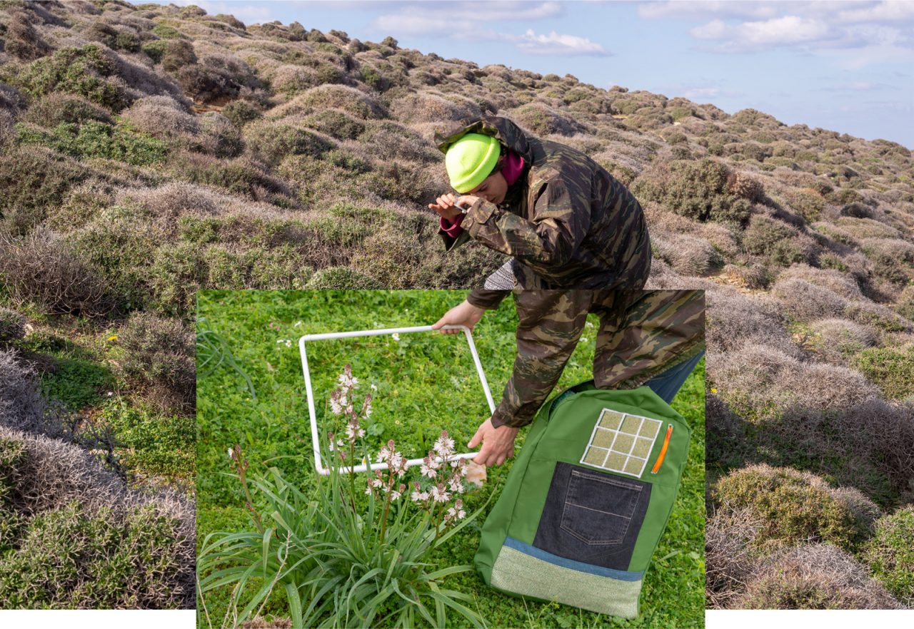
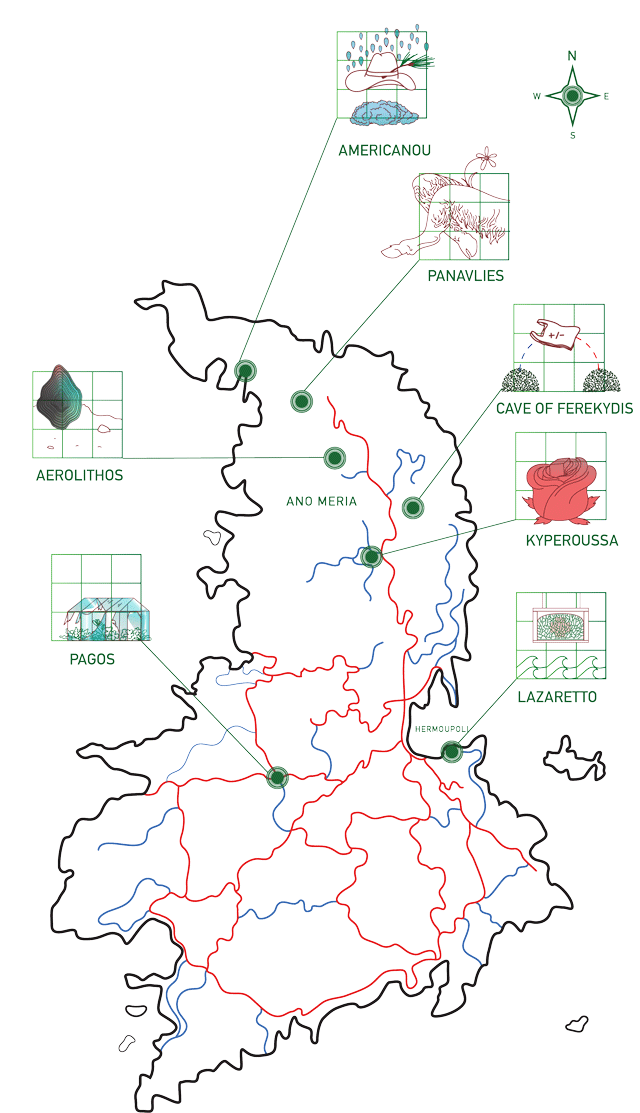
The digital herbarium presents portraits of botanical communities as frames for observations on multispecies ethnography, utilizing the method of photo-quadrats to archive multiple flora matrices from different locations in Syros. These botanical photo-quadrats create a basis for island residents to share their expertise, stories and archives on local flora. Each photo-quadrat is accompanied by precise geolocation and meteorological data, making it possible to revisit the same location for future comparative reference. The collection of this data is accomplished through a custom-built hub created by Kudzu Technologies, housed in a 3D-printed case designed by Adamantia Alexopoulou, and printed by the Department of Products and Systems Design Engineering at the University of the Aegean in Syros.
Anyone willing to participate in the construction of this public access archive can contribute to Anthemis, either by using the project toolkit, contained within a custom-sewn backpack, or by sharing their personal knowledge and audiovisual archives concerning the flora of Syros identified in the project’s photo-quadrats. The herbarium collaborates with a resident scientific team to accurately identify the plant species. Currently, this team is composed of botanist Nikos Kailis and ecologist and forestry expert Kostantinos Katagas, who have provided Anthemis with invaluable support and a wealth of material to kickstart the herbarium.
HOW TO CONTRIBUTE
There are three ways to contribute to Anthemis.
1. Use the toolkit
Take the Anthemis backpack on a walk as you explore and document plant biodiversity on Syros. No special knowledge of plant species is needed; just a love for nature and the desire to be a part of the collective construction of an archive of ecological observations. Team up with a friend and choose a location in Syros you wish to explore: it can be a small area or a large area, your school’s backyard or an entire hillside.
2. Provide photographic plant portraits
Anthemis has produced a plant database of Syros flora, which are used to provide information on plant species identified in the photo-quadrats; you can contribute to this database by providing photographic portraits of Syros plants.
3. Add audiovisual archives
Anthemis aims to build an archive of local knowledge, imagery, drawings, notes, texts, films and audio recordings documenting the flora of Syros, and/or illustrating peoples’ personal connections with local plant biodiversity. If you have materials related to the plants already included in the digital herbarium, you can submit them for review and inclusion.
To contribute, or for additional information, reach out to us via email at anthemis@archipelagonetwork.org.
BACKPACK AND TOOLKIT
The Anthemis backpack is waterproof and oversized, designed to safely hold the toolkit with additional space and easily accessible pockets to carry necessary and useful items when going out on a hike (water, snacks, clothing, first aid items, etc.)
The backpack contains the following toolkit:
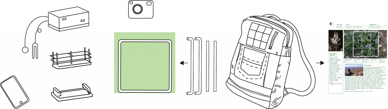
- A collapsible quadrat in 4 parts, which locks in place by applying pressure to the joints.
- The Anthemis data hub, containing a microcomputer designed by Kudzu Technologies and a variety of sensors to provide the date, time, geolocation, barometric pressure, temperature and humidity data, as well as soil moisture and a spectrogram of soil vibration frequencies where possible.
- A HD waterproof action camera for photographic documentation.
A notebook, in which each user of the backpack and toolkit may create a diary entry for the hike.
In order to access the hub and record data, you will need to use your smartphone to connect with it.
HOW TO USE IT
- First, identify a location on Syros island that you wish to explore, and contact Anthemis to express your interest in contributing to the digital herbarium and receiving the backpack. Visit the Anthemis online platform on the day before your observation walk, to get a sense of how the material you collect will be used.
- When you reach the location you plan to explore, start along your route or footpath observing the different plant species that inhabit the area. Locate specific spots along your route that are representative examples of the plant biodiversity.
- When you locate such a spot, open the backpack and take the four white metal rods out, assembling them and placing the resulting square frame on the ground. Take out the camera, and take a photo of your quadrat. Hold steady and make sure the lines of the quadrat are parallel to your photo frame.
- Put the quadrat aside, take out the Anthemis data hub and place it on the ground in the location the photo-quadrat was captured. If the soil where you place the hub is loose and penetrable, take out the two sensors included in the hub and push them fully into the ground. If the soil is not penetrable or you are in a spot that is mostly rock, leave the sensors in the hub.
- Take out your phone and press the record button on the hub. That’s it! The hub has recorded your exact geolocation, as well as the exact time, date and meteorological conditions of your location.
- Keep walking and choose a new location to document. Try and include as many of the species you encounter as possible; you are encouraged to collect a minimum of 9 quadrats per location.
- Use the notebook found in the backpack to add an entry for the day of your Anthemis walk. Include the names of all the people who joined you, briefly describing your walk, as well as any personal observations, thoughts or information you can share about the location’s history.
- If the location you are visiting is new and has not been previously included in the Anthemis database, you may contribute with the drawing or description of a simple symbol to represent the location, which will be used to make a quick reference icon on the website for the location you are introducing.
- Return the backpack. We will download the collected material, consult the resident botanist team to accurately identify as many species as possible, and upload your contribution on the Anthemis website.
- In the future you may revisit the same location, using the GPS coordinates recorded by the Anthemis data hub to locate and document the exact same area, in order to collect a new set of data to create a timeline of how that specific quadrat evolves in the future.